Next RPC Meeting: Tuesday, October 29, 2024
Note: Plans attached to the case numbers may not be the most current as revisions are submitted throughout the month.
We offer live-streaming video of the meetings via our YouTube page: https://www.youtube.com/@CMCRPC
Direct Link to Live Video (2 PM Central) October 29, 2024
Current Agenda
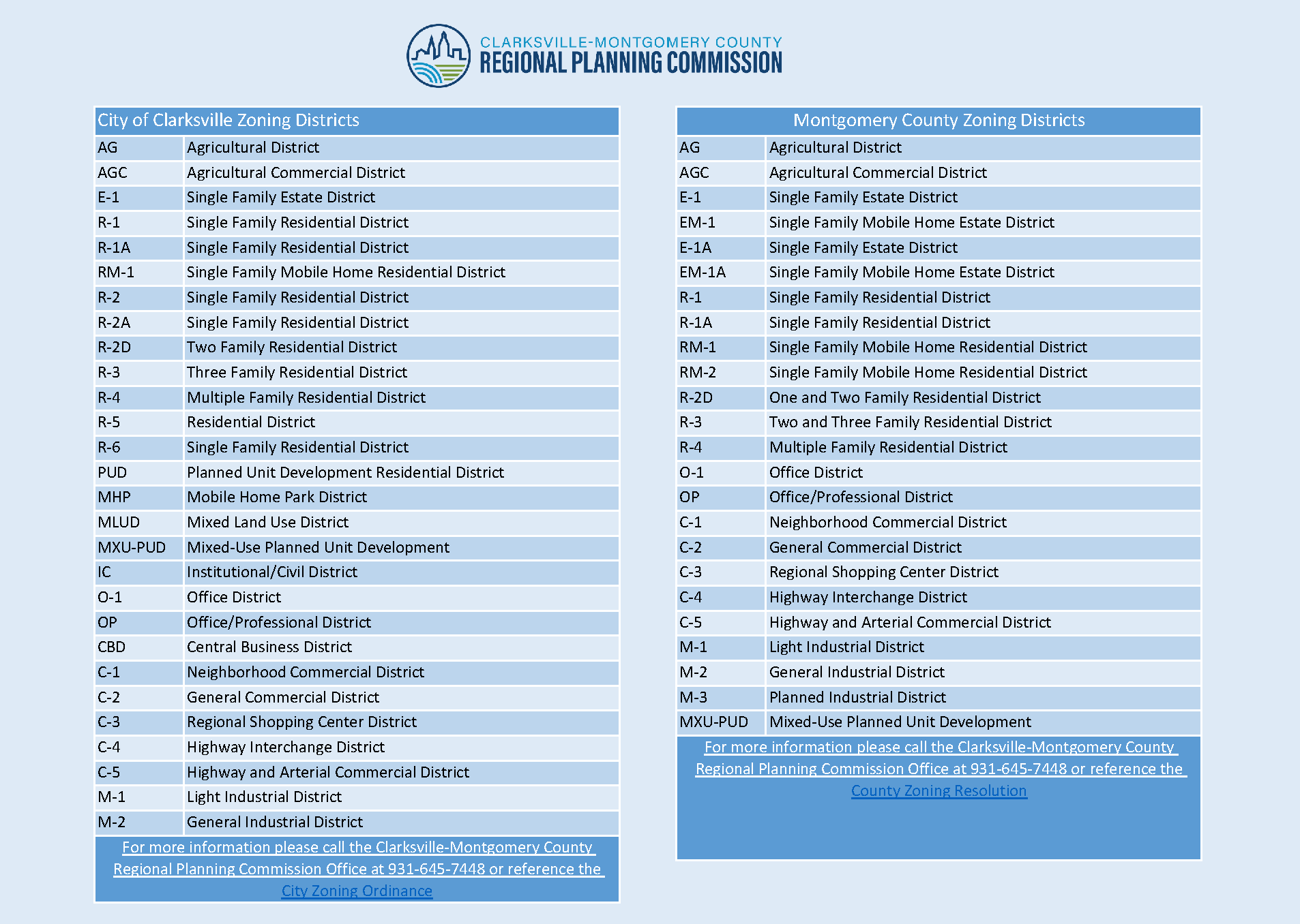
Zoning Cases
| Case # | Map | General Location | Rezoning Request |
|---|---|---|---|
| Z-34-2024 | A parcel of land fronting on the south frontage of Old Trenton Rd. 1,370 +/- feet west of the Wilma Rudolph Blvd. & Old Trenton Rd. intersection. | R-1 to R-2A | |
| Z-36-2024 | The southeast corner of the Cumberland Dr. & Southern Pkwy. intersection | R-1 to C-5 | |
| Z-37-2024 | Fronting the north frontage of Ashland City Rd, east of Horace Crow Dr,; west of Queens Bluff Wy. | M-1 to C-2 | |
| Z-38-2024 | Property located on the northern frontage of Adams Ct, approximately 130 feet west of the intersection of Adams Ct & Cumberland Dr | R-3 to C-2 | |
| Z-39-2024 | A portion of a tract of land fronting on the north frontage of Ringgold Rd. 300 +/- feet east of the Ringgold Rd. & Brentwood Cir. intersection. | AG/R-1/R-2 to R-5/R-6 | |
| Z-40-2024 | North of Needmore Rd, West of Teakwood Dr, North of and adjacent to Treeland Dr, South of and adjacent to Erie Dr | R-2 to R-4 | |
| Z-41-2024 | Parcel fronting on the west of Hornbuckle Rd., and east of Windermere Dr., north of the Hornbuckle Rd. and MLK Pkwy intersection. | C-4 to C-5 | |
| CZ-07-2024 | A parcel of land fronting on the west frontage of McAdoo Creek Rd. 675 +/- feet north of the McAdoo Creek Rd. & Poplar Hill intersection. | O-1 to C-2 | |
| ZO-2-2020 | Expansion of the Madison Street Urban Design Overlay Corridor up Hwy 76 | ||
| ZO-3-2024 | *DEFERRED* |
Subdivisions
Maps and Plats are preliminary and subject to change before the Planning Commission meeting.
| Case # | Map | Plat | Name |
|---|---|---|---|
| S-71-2024 | Bent Tree | ||
| V-12-2024 | Variance for Bent Tree | ||
| S-72-2024 | Longview Ridge Section 3 (Cluster) | ||
| S-73-2024 | 125 Sango Dr. | ||
| S-74-2024 | Ross Farms Section 1B Lot 113 |
Site Plans
Maps and Plans are preliminary and subject to change before the Planning Commission meeting.
| Case # | Map | Plan | Name |
|---|---|---|---|
| SR-37-2024 | Casey’s General Store | ||
| SR-44-2024 | Altra Credit Union | ||
| SR-57-2024 | Holland Park | ||
| SR-58-2024 | Chin Fa Yang Development | ||
| SR-59-2024 | Rinconcito’s Mexican Grill | ||
| SR-60-2024 | Needmore Road Retail | ||
| SR-61-2024 | Greenway Townhomes | ||
| SLSR-24-2024 | Charleston Oaks Clubhouse | ||
| AB-04-2024 | A portion of Underwood Rd, approximately .52 miles. | ||
| AB-05-2024 | A portion of Bales Rd, approximately .29 miles. |
Annexations
No current annexations
Common Design Review Board
October 28, 2024
Cancelled – no agenda items
| Case # | Map | Plan | Name |
|---|---|---|---|
Previous Month’s Zoning Cases (September)
| Case # | Map | General Location | Rezoning Request |
|---|---|---|---|
| Z-33-2024 | A tract of land fronting on the northern frontage of Ashland City Rd. 725 +/- feet west of the Ashland City Rd. & S. Rosewood Dr. intersection. | R-1 to R-4 | |
| Z-35-2024 | Property fronting on the north frontage of W. Rossview Rd., 775 +/- feet west of the Wilma Rudolph Blvd. & w. Rossview Rd. intersection. | R-1 to R-6 |